- Home
- /
- Nunn research
- /
- David Nunn in London
My ancestor, David Nunn, lived in London, but according to my grandad, he was born in Suffolk. Unfortunately, I can’t find him in any Suffolk records, although some researchers have identified him as the son of John Nunn and Mary Harrison, baptised in Burgate in 1789. I’m not sure that it’s him.
Pulteney Court, St James Westminster
While David’s marriage to Elizabeth Griffin at St George Hanover Square, in 1818, seemed like the earliest record he appears in, in fact it’s possible that there’s earlier records. These seem to place him in Pulteney Court, St James Westminster, in an area we’d refer to as Soho today. Pulteney Court extends east from Silver Street. Today, Pulteney Court is called Silver Place, and Silver Street is known as Beak Street. In the map below, taken from Horwood’s Plan (1792-9), you can see Pulteney Court towards the top right of the image.
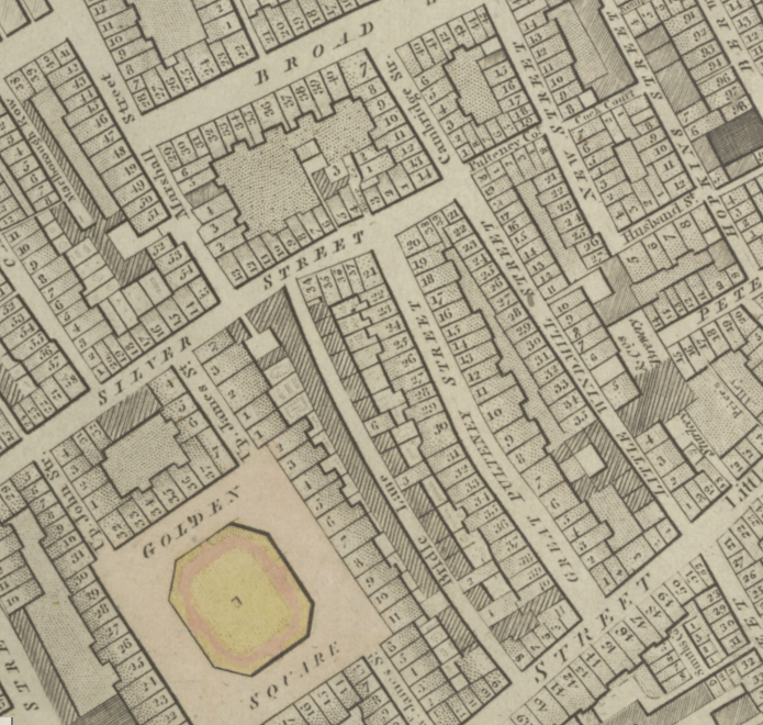
I say it “seems” to place David on Pulteney Court, because there’s an anomaly. The Land Tax records give little information, and the named person could be the tenant or the landlord. All I can find in the records for the 1810s are the streets, the named people being assessed, and the amount they were assessed for. And the problem is that the forename of Mr Nunn on Pulteney Court changes. In 1814 and 1815, he’s David Nunn; in 1816 and 1819, he’s Daniel Nunn! I have noticed, when transcribing, that it can sometimes be had to distinguish between David and Daniel, and that’s presumably what happened here – whoever was writing up the Land Tax register made a mistake. But which forename it’s meant to be, I don’t know. However, it’s possible that this was my ancestor.
The fire insurance records give some extra information, at least, about Mr Nunn’s neighbours. The Land Tax register starts with David Nunn as the first person on Pulteney Court, followed by William Mason, John Phillips, William Lainsbury (or Sainsbury), and Pretty. The fire insurance records tell us that William Mason, a butcher, was at #4 (1807-1812), John Phillips, a chandler, at #3 (1805-1809), and William Lainsbury, a tin man, at #2 (1806-1822). We can see from the numbering that Pulteney Court was (and Silver Place still is!) a very short street. There were only eight numbered properties on it, one on each side – nos. 1-4 on the south side, and nos. 5-8 on the north. Pretty was presumably at no. 1, so where was David? At #4 with William Mason, the butcher? I’m currently flicking through the 1815 Post Office London directory to list everyone on Pulteney Court and other streets nearby. It’s alphabetical by surname and David Nunn isn’t in there, but you never know who else might be and what clues it might provide. John Phillips is of particular interest, as David later became an oilman and tallow chandler.
When David and Elizabeth married, they both said that they lived in the parish of St George Hanover Square, but if David was living on Pulteney Court, he wasn’t, because it’s in the parish of St James, Westminster. There could be several explanations for this: the Pulteney Court Mr Nunn isn’t my ancestor; David was a landlord, not a resident, on Pulteney Court; they used a “suitcase address”, so were nominally but not literally resident in the parish; whoever filled out the marriage register made a mistake.
There is another possible reason for David being in St George Hanover Square – he could’ve been staying with relatives. Ezra King of Framlingham married Rose Nunn in Debenham in 1803. She was the daughter of Leonard Nunn and Rose Pipe. At the time of their marriage, Ezra lived in St James’, Westminster, but by 1814 the family were living on Bird Street in the parish of St George Hanover Square. Ezra was a carpenter and oilman – could David have partly followed in his footsteps after giving up his tobacconist’s to become an oilman and tallow chandler?
The Sun Fire insurance records show a John Nunn, victualler, at The Crown public house at 14 Great Crown Street, Pulteney Street, in St James Westminster between 1809 to 1824, not too far away from Pulteney Court. Was he related to David?
22 Windmill Street, Tottenham Court Road, St Pancras
We definitely know that David lived for a time at 22 Windmill Street in St Pancras. This street still exists, under the same name, leading west from Tottenham Court Road, a little south of the American Church (which is on the former site of Whitefield’s Memorial Chapel). The Charlotte Street chapel used to stand opposite the western end of Windmill Street.
Pulteney Court confused this somewhat, because if you walked west out of Pulteney Court and turned immediately south, you’d end up on Little Windmill Street, with no. 22 very close to the junction. But this is a red herring. David and Elizabeth’s first child, Sarah, was baptised at St Giles-in-the-Fields in April 1819, and their address was given as 22 Windmill Street, St Pancras. It would be interesting to know why Sarah was baptised there, when it wasn’t in their parish. Did they have family in that parish?
On 24 August 1819, an advert appeared in the Morning Advertiser. Particulars for a “house and shop, in the general line, with a mangle” in Camden Town could be had from “Mr. Nun, 22 Windmill Street”, Tottenham Court Road.”
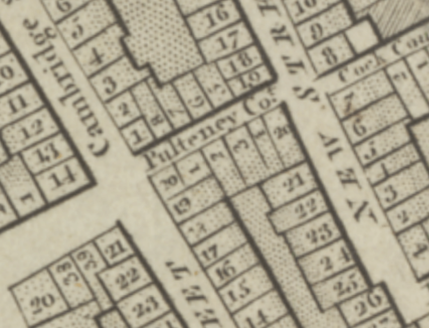
Referring back to the Land Tax records, in 1819, we still have “Daniel Nunn” on Pulteney Court, and “David Nunn” on White Hart Court in St Pancras.
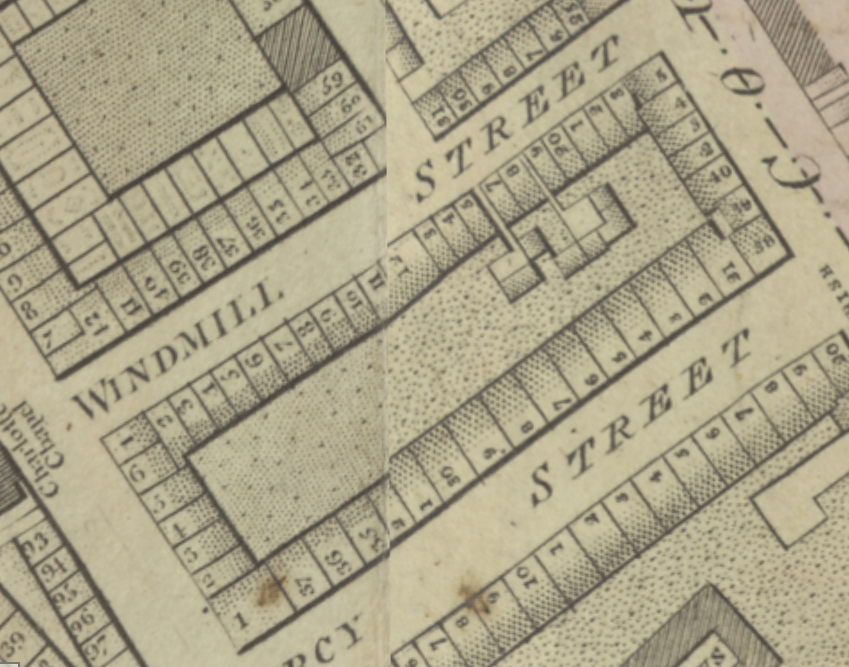
White Hart Court caused me a lot of head-scratching, until I worked out that that there was a public house called the White Hart at no. 17 Windmill Street; at the time, it was run by a widow called Charlotte Leaton, who died in about 1821. Looking at Harwood’s Plan again, I spotted a court that leads off between no. 15 and no. 17 Windmill Street. That must be White Hart Court. It’s only a few doors down from no. 22 Windmill Street.
White Hart Court looks very small on the plan, but I counted no less than 25 people in the Land Tax records on that street. The David Nunn at White Hart Court is presumably my ancestor, but we know he was at no. 22 – perhaps he was the landlord there, and because he’d been rated at that address, wasn’t placed on Windmill Street.
David was working as a tobacconist from his address on Windmill Street, but he changed profession only a few years later, becoming an oilman and tallow chandler. It may or may not be significant that Elizabeth’s first cousin Charlotte Griffin married William Collins, a tobacconist who lived and worked in Holborn, London. It’s possible that David, being a tobacconist, knew William Collins, and through his wife, Elizabeth. David could have become an oilman and tallow chandler via Elizabeth’s brother, Thomas Griffin. Thomas had been apprenticed as a grocer, but worked as an oilman and tallow chandler, and often grocers do work as oilmen or chandlers as well. And there’s also the possible link with Ezra King, carpenter and oilman mentioned above.
It may be significant that Windmill Street is so close to Whitfield’s Memorial Chapel. According to my grandad, David’s family were Methodists, even having a letter from John Wesley tucked into their family Bible (known as “the farm Bible”, which my great-grandmother lost/buried in the garden with rubbish during a house move) although all of David and Elizabeth’s children were baptised in the Church of England.
Windmill Street is also very close to Tavistock Street (in the bottom-right of the larger map above the close-up of Windmill Street). At the time David was on Windmill Street, Joshua Nunn was at 8 Tavistock Street, working as a tea dealer. He was the son of William Nunn of Romford, from a Nunn family who were originally from Debenham and Earl Stonham in Suffolk. Joshua’s son Francis was baptised at St Giles-in-the-Fields in 1823, the same church that David’s first child was baptised at in 1819. This was Joshua’s parish, but not David’s – could there be a connection between Joshua and David which explains the choice of church? Or is it just a coincidence?
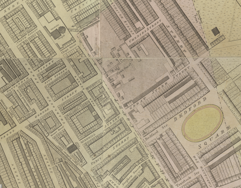
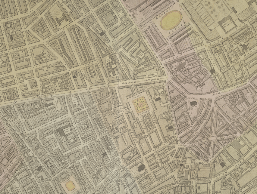
This plan below shows the journey David may have made from Pulteney Court, north to Windmill Street. Pulteney Court is slightly north-east of Golden Square (which you can see towards the bottom left). And Windmill Street is towards the top of the image, in the middle, with Bedford Square to the east, and the black square of Charlotte Chapel immediately to the west. It’s a distance of about half a mile, and would take about 10-15 minutes to walk, crossing Oxford Street.
132 Shoreditch High Street
In 1820, David appears in Kelly’s Directory at 132 Shoreditch, working in his new career as a tallow chandler, and he would be at that address for nearly 20 years. The baptisms of David and Elizabeth’s children, at St Leonard’s, Shoreditch (a church which was almost directly opposite them) gives their address as Holywell Street. This was the old name for Shoreditch High Street, not to be confused with Holywell Lane, which goes west off the High Street, further south. You can see from Horwood’s Plan (below) just how close they were living to the church.
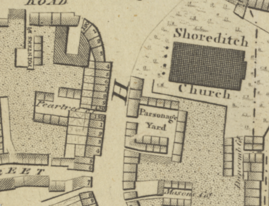
No. 132 is almost opposite Parsonage Yard on Harwood’s Plan, but John Tallis’s London Street Views, which shows David’s shop, including the oil vase over the door which helped illiterate customers find his shop, shows the shop as being directly opposite the entrance to a road. Parsonage Yard was presumably done away with, and Calvert Street was run through. Today (February 2024), no. 132 is occupied by “Match Box”, “Right in the hart of trendy Shoreditch is a sports bar all the big events on large screen TV’s (not just football).” No chance of buying candles or lamp oil there, then!
Eight of David and Elizabeth’s ten children were baptised at St Leonard’s, the address given as Holywell Street, or Shoreditch, before the family moved to Aldersgate in the late 1830s. However, it seems that even before their move, David was expanding the business, as his name is connected with a couple of other addresses.
31 Winchester Street, Waterloo Town, Bethnal Green
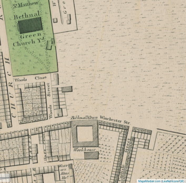
David Nunn, oilman, was insured at this address on 9 Dec 1828. I don’t have any reason to suspect this was another David Nunn, oilman. In 1828, Winchester Street was a very new road. It’s now Dunbridge Street, where the famous Repton Boxing Club can be found, and is slightly south-east of St Matthew’s church. The road was first developed in 1818, as an eastern extension of Hare Street (now Cheshire Street), extending out across what was then farmland (yes, farmland in Bethnal Green, as hard as that is to picture now!). Faden’s 1819 revision of Horwood’s earlier Plan of London shows Winchester Street numbering from 1 to 16. David’s property was yet to be built. At the time he insured the business at that address, the area was developing rapidly with new buildings shooting up – you can see why he decided to expand east.
But he doesn’t appear at that address again. Instead, he went west.
23 Ebury Street, Pimlico
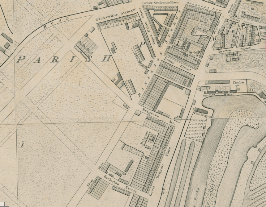
The area now known as Pimlico (it’s impossible for me to see the name “Pimlico” without thinking of the classic film “Passport to Pimlico”!) used to be known as Ebury, as it was the Manor of Ebury – this is where the name of the street comes from. The area was marshy, with docks, and wasn’t developed until the early 1800s. This is why, like Winchester Street, Ebury Street is nowhere to be found on Horwood’s Plan in the 1790s. Faden’s 1819 revision of Horwood shows how Ebury Street was slowly coming to life. On the map, you can see the route of the street has been marked out, and at its northern end, it’s called Ranelagh Street, a name it lost. Towards the bottom of the map, you can see Ebury Place, with Eccleston Street leading away to the east. If you carried on going south-west, you would soon be at the Chelsea Hospital.
David Nunn insured 23 Ebury Street on 4 Nov 1840, for his “grocer and Italian warehouse” business. At the time, this was a new, smart area, and it’s possible that the use of “Italian warehouse” instead of the more humble “oilman and tallow chandler” reflects David’s clientele; the terms mean exactly the same thing.
Robson’s Directory for 1840 names William Grant, linen draper, being at the address, but perhaps he moved during the year as David’s insurance is dated from towards the end of 1840. In 1845, William Kent, saddler and harness maker, was at no. 23, according to the Post Office directory for that year (I don’t have access to the intervening years, and Ebury Street isn’t numbered on the 1841 census). This entry gives us information to help place the property on Ebury Street. The street runs from Lower Belgrave Street to Elizabeth Street, and at no. 29, we find the Crown and Anchor pub, run by Thomas Jones in 1845. Then Ecclestone Street south intersects, so the pub was, like many pubs still are, on a corner. Looking back at the 1819 map, we can position no. 23 very easily – it was empty land at the time, but the plot was a few doors north-east from what was then Ebury Place.
110 Aldersgate Street, City of London
The family’s business is listed at 132 Shoreditch in the 1839 edition of Pigot’s Directory, but by the 1841 Kelly’s Directory, they’re at 110 Aldersgate Street. This a long road which leads north from St Paul’s Cathedral, past the church of St Botolph’s Aldersgate, and in an area now known as the Barbican. Back then, it was the northernmost boundary of the City of London. Looking at Faden’s 1819 revision of Horwood, in the centre of the following image, we can clearly see 110 Aldersgate’s position:
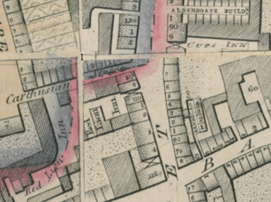
Carthusian Street, sliced in two by the boundary of the City of London, runs west from Aldersgate Street, just a couple of doors up from no. 110. Google Street View helpfully shows that the Nunns lived next door to what is is now a Tesco Express – very convenient! The Red Lion Inn was on their doorstep, run at the time by Thomas Pepper and his family, which you can read about on the London Pub Wiki. Over the road and slightly to the north of the Nunns’ home was The Cups Inn, run by William Smith. Again, there’s a page on the London Pub Wiki with more information.
Nowadays, just a few doors south of 110’s site, is Barbican Tube station. I’ve been through it many times, travelling from Euston to Liverpool Street in order to visit family in Essex, and it feels rather fitting that the journey takes me past what was once my ancestors’ home. In fact, I was left sitting on the platform at Barbican station once, waiting for a train to take me to writing awards’ ceremony. I knew the Nunns had lived close by so I felt a sense of calm and belonging there. It’s only now, looking in detail at the maps and comparing them to the modern street layout, that I can see just how close I was to where they had once lived.
On the night of the 6th June 1841, the census was taken, and David was at home at no. 110 Aldersgate, with most of his large family:
- David Nunn 50 tallow chandler, not born Middlesex
- Elizabeth 40, not born Middlesex
- Charlotte 14, born Middlesex
- Mary A 8, born Middlesex
- Harriet 6, born Middlesex
- Alexander 4, born Msex
- William Butcher, 19, porter, born Middlesex
- Eliza Luke, 18 servant, born Middlesex
I haven’t yet found their eldest daughters, Sarah and Elizabeth, on the 1841 census. Their son Samuel (my 2 x gt-grandfather) was a pupil at Joseph Stansbury’s school on St Matthew’s Place in Bethnal Green. There was another person in the household that night, sort of, who doesn’t appear on the census: Elizabeth was pregnant with her tenth child.
But only a couple of months after the census was taken, tragedy befell the family. David was taken ill – apparently unexpectedly, because he didn’t write a will before his death at no. 110 on 24 August 1841. He was 55 years old. His widow Elizabeth was left with the children to raise and a business to run. She appears to have been a stoic lady; she registed David’s death the very next day. She appears to have tried to continue the running the business from the same address, as Lydia was born at no. 110 Aldersgate on 8 October 1841, 6 weeks after her father’s death. Lydia was baptised at St Leonard’s Shoreditch the following year, while the family still lived on Aldersgate Street, but a short while afterwards, they returned to Shoreditch High Street, where Elizabeth changed the family business: gone were the oil and candles, the shop was filled instead with bonnets and hats as she became a milliner and dressmaker.
On 29 August 1841, David Nunn was buried in the parish churchyard at St Botolph’s Aldersgate. That space is now Postman’s Park, next to the former site of the General Post Office’s HQ. It’s a small green space for the public, which honours civilians who died trying to save others’ lives. David is under there, somewhere. Perhaps it’s fitting for someone who lived at so many addresses to have Postman’s Park as his final address.